
North Bend sits at the center of one of the most accessible and diverse trail networks in the Pacific Northwest. Whether you are lacing up hiking boots for the first time or looking for a technically demanding ride through old-growth forest, the trails here are built for all levels of experience and all types of outdoor pursuits.
From flat, paved valley paths well-suited for families and casual riders to rugged single-tracks that challenge even experienced cyclists and hikers, North Bend's trail systems span a wide range of terrain, distance, and difficulty. The Raging River Trail System, Tennant Trailhead Park, Boxley Creek Trail System, and the Snoqualmie Valley Trail are among the most frequented, each offering its own character and its own rewards.
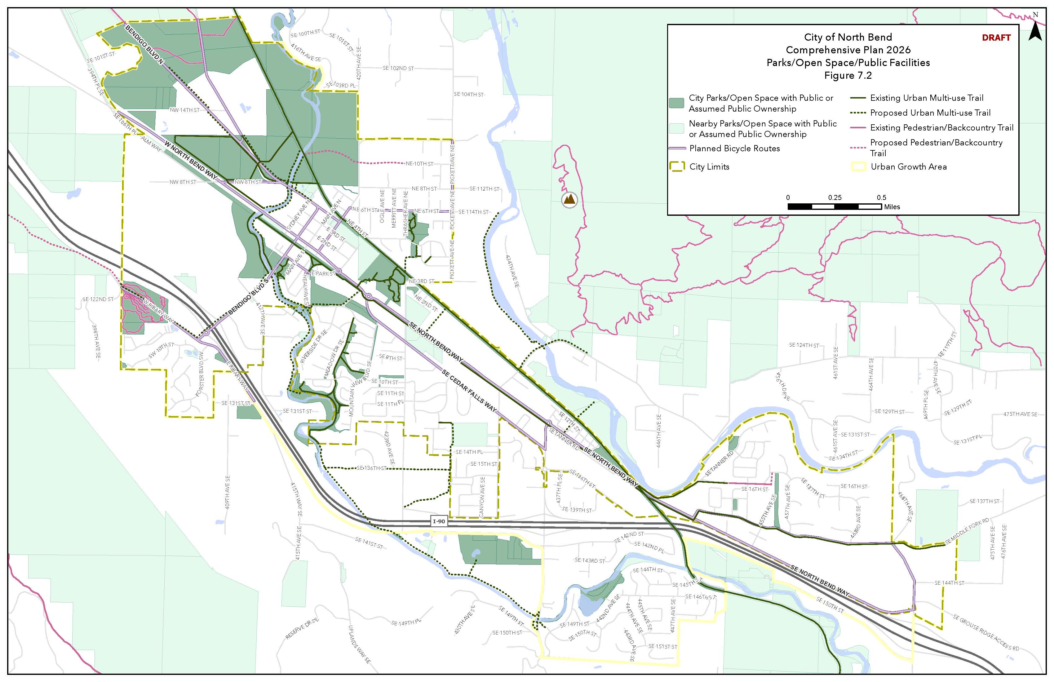
The map below provides a full overview of hiking and cycling paths in and around North Bend. Use it to find the trail that fits your pace, your skill level, and your day.
Understanding who lives and works in North Bend is an important starting point for any business considering the area. The following data reflects the city's demographic profile, household economics, and employment landscape.
North Bend's trail systems offer something for every level of rider, set against a backdrop of forested hills and river valleys. The Raging River Trail System, Tennant Trailhead Park, and Boxley Creek Trail System are among the most popular, featuring routes that range from rugged single-tracks for experienced cyclists to accessible, family-friendly paths. Each system winds through North Bend's rich natural landscape, making them well worth a visit year-round.
North Bend's trails invite hikers to explore the region's forests, ridgelines, and river corridors at their own pace. Many of the same trail systems open to cyclists also welcome hikers, offering routes for a range of skill levels. Please note that certain trails are designated for cyclists only therefore check individual trailhead signage or contact the City for details before heading out. From the Raging River trails to Tennant Trailhead Park and Boxley Creek, there are rewarding routes for every kind of hiker.
North Bend's parks offer a wide range of outdoor experiences, from team sports and fishing to cycling, climbing, and wildlife observation. The City manages and maintains these parks and recreational areas, ensuring well-kept facilities and accessible open space for residents and visitors alike.
North Bend's parks and open spaces include:
Tennant Trailhead Park is a 32-acre green space located on the southwest border of North Bend, south of Exit 31 off I-90. The park sits on Rattlesnake Mountain and offers an extensive network of mountain biking and hiking trails for all skill levels, from absolute beginners to advanced riders. The park also preserves wildlife habitat and is home to mature forests, wetlands, creeks, steep topography, and glacial erratic rock features.
Tennant Trailhead Park is located south of Exit 31, on either side of Ribary Way.
Park hours are 7 am to dusk daily.
The Raging River mountain bike trails are best known for the "lollipop" — a ride slightly under 20 miles that combines the full range of the trail system. There are trails for various levels of experience. Below is a list of several popular biking trails, but the entire list of trails can be found on TrailForks.
Family (Kids Loop) Green | 440 ft | -20 ft descent | 16 ft climb
Family (Kids Loop) is a short, popular multi-use trail that can be used in both directions. It is a well-suited starting point for young riders getting comfortable on a bike.
Flying Bee Green | 1,027 ft | -48 ft descent
Flying Bee is a great trail for mountain biking, e-bikes, and hiking. This trail can only be used downhill. Mountain bikers will encounter a few rollers — mounds of dirt on a trail that can be pumped or jumped on a bike.
Climbing Stumps (Climbing Trail) Green | 1,486 ft
Climbing Stumps is a popular green singletrack multi-use trail that can only be used uphill. This long, flowing trail starts near the parking lot and connects to Jumping Spider a third of the way down the path, and to the South Climb Connector two-thirds of the way down. The South Climb Connector allows mountain bikers to navigate Jumping Frog, Twisty, and Flying Bee. Both Jumping Frog and Twisty are specifically dedicated to mountain biking.
Jumping Spider Blue | 643 ft | -26 ft descent
Jumping Spider consists of clean tabletops, a few lips, and directs you to the Climbing Trail. This is a mountain bike primary trail that can only be used downhill.
Raccoon Blue | 1,004 ft | -82 ft descent
Raccoon is a popular singletrack trail that can only be used downhill and is known for being technical. Riders will encounter rocks, berms, pockets, and a few drops, including a tabletop. The trail redirects back to Climbing Woodpecker or can be taken across the road via the N Side Connector.
Climbing Woodpecker Blue | 1,224 ft | 79 ft climb
Climbing Woodpecker connects mountain bikers to Raccoon via a steady climb and winding path.
Bobcat Black | 295 ft | -24 ft
Bobcat is a narrow trail with a few jumps and berms that weaves through the trees along the path.
Jumping Frog Black | 643 ft | -26 ft
Jumping Frog is popular for its jumps, berms (banked turns), and pumping (generating speed without pedaling).
Elk Black | 906 ft | 0 ft
Elk starts with a rock meant to be biked up and over. Riders will then encounter a jump followed by a gap and a drop, leading to a range of trail options.
The trailhead plaza has parking for 30 vehicles, along with a restroom and picnic tables.
Washington offers good riding conditions throughout much of the year, though Tennant Trailhead Park is not the best winter riding destination. The upper trails receive snow, and the flow trails can be muddy and slippery during heavily wet periods. Riding in these conditions can also cause trail damage.
Tennant Trailhead Park is open to non-motorized users and closed to equestrian use. Some trails are designated hiker only or biker only therefore please adhere to all posted safety signs. The park is predominantly dedicated to mountain biking, so hikers should remain aware of cyclists on the trails. Most trails are designed to be ridden in one direction only.
The Raging River Trail System, located in Raging River State Forest, is a 17-mile singletrack trail system primarily for mountain biking and hiking. Situated in the Rattlesnake Mountain area, the system offers a wide range of trails for beginners through to experts, making it one of the most well-regarded trail systems in the greater Seattle area.
From I-90 Eastbound, take Exit 27. Instead of going under the freeway towards Snoqualmie Casino, turn right onto Winery Road. You can park here or continue to the main parking lot.
Park hours are 7 am to dusk daily.
The Raging River mountain bike trails are best known for the "lollipop" — a ride slightly under 20 miles that combines the full range of the trail system. There are trails for various levels of experience. Below is a list of several popular biking trails, but the entire list of trails can be found on TrailForks.
Way Back! (North) Green | 5,180 ft | -35 ft descent | 306 ft climb
Way Back! (North) is an easy two-way multi-use trail with low elevation loops. This trail serves multiple purposes including providing a singletrack connection to and from Lower Return Policy. Mountain bikers will encounter low elevation loops and Way Back! (North) provides a connection to Tiger and Taylor Mountains.
Raging Tiger Green | 3 miles | -36 ft descent | 639 ft climb
Raging Tiger is a two-way multi-use trail that begins past the Canyon Creek bridge. The trail climbs to near the top of Upward Mobility, meeting the trail at Dash — a short connector trail. Raging Tiger climbs in brief steep stints followed by a break in the climbing grade, making it a manageable ascent for riders building their fitness and skills.
Upward Mobility Green | 3 miles | 1,059 ft climb
Upward Mobility is a one-way climbing trail that allows access to the Raging Ridge Trail as well as Poppin' Tops and Flow State. This trail winds gradually through the forest.
Raging Ridge Blue | 6 miles | -313 ft descent | 1,625 ft climb
Raging Ridge is a two-way trail that climbs from Stan's Lookout and the top of Upward Mobility to the highest point in the trail system, offering some of the broadest views of the surrounding landscape. No Service, a descending trail, can be reached at the end of Raging Ridge. The climb is steady and the ride down features smooth tread with good sight lines. The singletrack winds through tall forest and clearcut areas. Near the far end of Raging Ridge the terrain becomes more advanced and technical — consider your skill and fitness levels before continuing through the steep and rough trails or heading back.
Flow State Upper Blue | 2,402 ft | -292 ft descent
Flow State Upper is a descending only mountain bike trail. Mountain bikers will encounter several jumps along the winding path as well as some narrow turns. The lower section is more approachable for riders building confidence, featuring smooth terrain and berms.
Poppin' Tops Lower Blue | 2,178 ft | -203 ft descent
Poppin' Tops Lower is an intermediate trail that descends along bermed turns and small jumps with some technical skills needed. This is a good trail for riders looking to develop their skill level.
Poppin' Tops Upper Black | 2,365 ft | -193 ft descent | 21 ft climb
Poppin' Tops Upper is a descending only trail meant for advanced riders. This trail is more challenging than Poppin' Tops Lower and Flow State. The progression allows mountain bikers to work their way up the mountain before descending. Riders will encounter berms, drops, and jumps.
No Service Black | 1.7 miles | -1,254 ft descent
No Service is a technically demanding descent that covers a range of terrain, from fast and technical root sections to open flow. The first section is the most technical, with roots throughout. This can be a slippery and challenging descent that stays wet long after rainstorms. The middle section eases on the technicality with a flow section featuring tabletops and rollers before finishing on a technical note.
Reverence Black | 1.9 miles | -1,200 ft descent
Reverence is a downhill only singletrack trail with roots, rocks, technical terrain, and a short flow section. This trail sits on the more approachable end of black diamond trails at the Raging River Trail System and leads to Canyon Creek DH and Upper PT.
Please be aware that a Discover Pass is required to park in the upper lot. Those without a Discover Pass are welcome to park along Winery Road.
Washington offers good riding conditions throughout much of the year, though Raging River is not the best winter riding destination. The upper trails receive snow, and the flow trails can be muddy and slippery during heavily wet periods. Riding in these conditions can also cause trail damage.
The Raging River Trail System has two distinct sides — the front side, with easier flow trails, and the backside, with rooty and raw advanced and expert riding. The Raging River lollipop combines both. The backside riding is deep in the backcountry and without cell service therefore make your risk assessment accordingly. Dogs are welcome but must be on a leash.
Boxley Creek is a King County Natural Area located southeast of North Bend in the Edgewick area. The Natural Area is divided in two by the Snoqualmie Valley Trail on its east side. Boxley Creek is a popular destination for mountain biking, hiking, trail running, and horseback riding.
There are several ways to arrive at Boxley Creek given that it is bisected by the Snoqualmie Valley Trail. From North Bend Way, travel 2.15 miles up the Snoqualmie Valley Trail from where it crosses North Bend Way. From the Christmas Lake Trailhead, travel 2.4 miles down the Snoqualmie Valley Trail.
Park hours are 7 am to dusk daily.
Boxley Creek provides a network of predominantly beginner and intermediate-friendly mountain biking trails. Below is a list of several popular bike trails, but the entire list of trails can be found on TrailForks.
Horse Shoes East Green | 719 ft | -18 ft descent
Horse Shoes East is a moderately popular green singletrack trail that can be used in both directions. The altitude change is minor and the trail is relatively short, making it a good introductory option for newer riders. This trail connects directly to both the Snoqualmie Valley Trail (Climb to Rattlesnake Lake) and the intersection of Backdoor Entrance West and Aaron's Enduro.
Boxley Creek Main Gate to Summit via Access Road Green | 3,314 ft | -64 ft descent | 198 ft climb
Boxley Creek Main Gate to Summit via Access Road is a popular, family-friendly singletrack trail primarily used for mountain biking. The trail can be used in both directions and has a moderate overall physical rating given the climb that starts at a distance of 1,447 ft from the intersection of the trail that crosses Mainline.
Aaron's Enduro Bypass South Green | 404 ft | -8 ft descent
Aaron's Enduro Bypass South is a popular singletrack primarily used for mountain biking. This trail has a soft descent and connects Mainline to Backdoor along with Aaron's Enduro Bypass.
Ethan's Enduro Course Blue | 3,156 ft | -227 ft descent | 8 ft climb
Ethan's Enduro Course is a singletrack trail primarily used counter clockwise. This is a fast downhill descent to the Snoqualmie Valley Trail or a moderate climb when ridden clockwise. When traveling counterclockwise, around the 2,718 ft mark riders will encounter a log drop or jump with a prominent bypass available.
Aaron's Enduro Blue | 1,302 ft | -79 ft descent
Aaron's Enduro is a multi-directional trail with a slight climb that is mostly ridden downhill when traveling from north to south. This trail is rooty and presents technical elevation changes that require careful line selection at higher speeds.
Mainline Blue | 3,691 ft | -15 ft descent | 226 ft climb
Mainline is a multi-directional trail and the main route to climb from the Snoqualmie Valley Trail to the downhill trails that start at the top of Boxley Creek. This path is generally flowing with a few climbs. Many trails at Boxley Creek connect to Mainline and these offshoots can be mistaken for Mainline. Mainline is marked by orange tape to assist riders in staying on course.
Power Line Exit Black | 604 ft | -92 ft descent
Power Line Exit is a singletrack trail primarily used by mountain bikers and generally ridden downhill.
Parking is available 2.15 miles up the Snoqualmie Valley Trail from where it crosses North Bend Way, 2.4 miles down the Snoqualmie Valley Trail from the Christmas Lake Trailhead, or 2.6 miles from the first Rattlesnake Lake parking area.
Washington offers good riding conditions throughout much of the year, though Boxley Creek is not the best winter riding destination. The upper trails receive snow, and the flow trails can be muddy and slippery during heavily wet periods. Riding in these conditions can also cause trail damage.
Boxley Creek is a popular area for mountain biking, hiking, horseback riding, and trail running. For those in the beginner and intermediate range, this is an excellent location to build and practice mountain biking skills as most trails are beginner or intermediate-friendly. More experienced riders should note that there is only one black diamond trail at this location.
One of the most iconic gravel mountain biking paths that crosses through North Bend is the Snoqualmie Valley Trail (SVT). This is a 29 mile gravel trail that stretches from Rattlesnake Lake outside of North Bend and ends at McCormick Park in Duvall. The Palouse to Cascades State Park Trail spans much of the state of Washington with a segment in North Bend. The Middle Fork Snoqualmie River area is known more for its gravel and mountain biking routes rather than transitional road cycling, though the initial part of the road is paved and can be cycled with a road bike.
Snoqualmie Valley Trail (North Bend to Snoqualmie) White | 5 miles | -94 ft descent
This 5-mile segment of the Snoqualmie Valley Trail connects North Bend to Snoqualmie and is relatively easy to ride. The trail runs between North Bend Way and SE Reinig Road in Snoqualmie.
Snoqualmie Valley Trail (Climb to Rattlesnake Lake) White | 5.7 miles | -13 ft descent | 426 ft climb
Snoqualmie Valley Trail (Climb to Rattlesnake Lake) is the eastern leg of the Snoqualmie Valley Trail. When starting from the part of the trail that crosses under I-90 there begins an easy climb to Rattlesnake Lake. The path provides view of the river and leads to a consistent climb that levels off the closer you reach the lake.
Palouse to Cascades State Park Trail (PCSPT) - Snoqualmie Pass-Rattlesnake Lake Green | 8 miles | -849 ft descent | 199 ft climb
Palouse to Cascades State Park Trail (PCSPT) - Snoqualmie Pass-Rattlesnake Lake is an 8-mile gravel path that is family friendly. This multi-use trail can be used in both directions and takes on average about 32 minutes to complete. The trail offers scenic views of the surrounding mountains.
Middle Fork Black | 13.7 miles | -1,291 ft descent | 3,025 ft climb
Middle Fork is a challenging singletrack trail that is multi-directional. This trail follows the Snoqualmie River and is technically difficult, though it is a PNW classic. The majority of the trail falls under a heavy canopy of trees and is surrounded predominantly by giant old-growth trees, ferns, streams, dense forest, roots, and creek crossings, and passes a natural hot spring. A portion of the trail is made of clay and therefore becomes slick in rainy conditions. Riders should be prepared for dismounting their bikes every now and then as there are numerous climbs.